

The Ministry of Interior and National Administration has identified 18 counties and three major cities requiring priority preparedness and response measures ahead of the anticipated El Niño season.
According to the ministry, the counties were flagged following a national risk assessment prepared by the National Disaster Operations Centre (NDOC), which assessed areas most vulnerable to flooding, landslides, drought, food insecurity, disease outbreaks and other El Niño-related impacts.
In a statement shared on X, the ministry said the affected counties have been prioritised to enable government agencies and stakeholders to strengthen disaster preparedness and minimise the impact on residents.
“18 counties have been identified requiring priority preparedness and response measures because of their exposure to flooding, landslides, drought, food insecurity, disease outbreaks and other possible El Niño related impacts,” the ministry said.
Coastal, Lake Basin and Rift Valley counties among the most vulnerable
The assessment places five Coastal counties—Tana River, Kilifi, Lamu, Mombasa and Kwale—among the highest-risk areas. The region faces threats including flooding, storm surges, coastal erosion, infrastructure damage and displacement.
In the Lake Basin region, Kisumu, Busia, Siaya, Homa Bay and Migori have been listed because of the risk of flooding, landslides, disease outbreaks, waterborne illnesses and displacement.
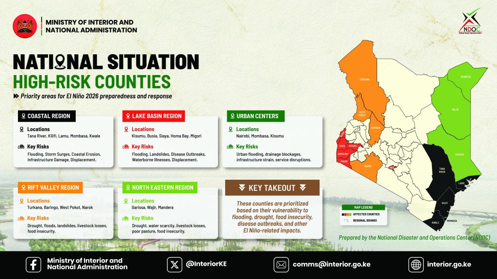
The Rift Valley counties of Turkana, Baringo, West Pokot and Narok were also identified as vulnerable due to a combination of drought, floods, landslides, livestock losses and food insecurity.
Meanwhile, Garissa, Wajir and Mandera in the North Eastern region have been classified as high-risk because of prolonged drought, water scarcity, poor pasture, livestock losses and food insecurity.
Nairobi, Mombasa and Kisumu listed as high-risk urban centres
The report also singles out Nairobi, Mombasa and Kisumu as high-risk urban centres because of the increased likelihood of urban flooding, blocked drainage systems, pressure on infrastructure and disruptions to essential services.
According to the Ministry of Interior, the counties and cities were prioritised based on their vulnerability to flooding, drought, food insecurity, disease outbreaks and other El Niño-related impacts.
The ministry urged relevant agencies and county governments to enhance preparedness measures to reduce the effects of severe weather events and protect lives, livelihoods and critical infrastructure.
Text extracted from the graphic
National Situation – High-Risk Counties
- Priority areas for El Niño 2026 preparedness and response.
Coastal Region
- Locations: Tana River, Kilifi, Lamu, Mombasa, Kwale.
- Key risks: Flooding, storm surges, coastal erosion, infrastructure damage, displacement.
Lake Basin Region
- Locations: Kisumu, Busia, Siaya, Homa Bay, Migori.
- Key risks: Flooding, landslides, disease outbreaks, waterborne illnesses, displacement.
Urban Centers
- Locations: Nairobi, Mombasa, Kisumu.
- Key risks: Urban flooding, drainage blockages, infrastructure strain, service disruptions.
Rift Valley Region
- Locations: Turkana, Baringo, West Pokot, Narok.
- Key risks: Drought, floods, landslides, livestock losses, food insecurity.
North Eastern Region
- Locations: Garissa, Wajir, Mandera.
- Key risks: Drought, water scarcity, livestock losses, poor pasture, food insecurity.
Key takeaway
- These counties are prioritised based on their vulnerability to flooding, drought, food insecurity, disease outbreaks and other El Niño-related impacts.